TECHNOLOGY section
3. 3D Seismic
Seismic reflection imaging is based on the principle that acoustic energy (sound waves) will bounce, or "reflect" off the interfaces between layers within the earth's subsurface. This principle is analogous to the process of a human voice echoing off of a building wall.
Exploration for oil and gas involves the evaluation of a variety of information. Well logs provide detailed information at specific locations, usually an area less than one meter surrounding the well bore. We use our knowledge of formation signatures to recognize depositional environments and try to project this information between wells.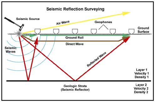
Reflection seismic methods can be used to create images of the geologic changes between wells. These images can help complete a picture of the subsurface that should enhance the ability of the explorationist to successfully select future well locations. Seismic is an effective tool as long as it provides meaningful and helpful images for the desired objectives. The seismic tool must provide a cost efficient alternative to additional drilling.
During a seismic reflection survey acoustic energy is imparted into the earth with a seismic source. H-LA&D typically uses noninvasive sources on our projects, such as a sledgehammer or a power-assisted weight drop source. These sources are impacted upon an aluminum strike plate ground surface to create high frequency seismic energy. After impact of the source the sound waves propagate and spread out along spherical wave-fronts in all directions. The usable sound energy travels into the earth (signal), while some energy is lost into the air or along the ground surface (noise). The figure on the right shows a simplified cross-sectional view of a 2D seismic recording system with some of the signal and noise ray paths associated with a reflection survey.
Since 2D data collection occurs along a line of receivers, the resultant image represents only a section below the line. Unfortunately this method does not always produce a clear image of the geology. 2D data can often be distorted with diffractions and events produced from offline geologic structures, making accurate interpretations difficult.
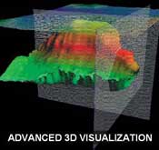
Because seismic waves travel along expanding spherical wave-fronts they have surface area. A truly representative image of the subsurface is only obtained when the entire wave field is sampled. A 3D seismic survey is more capable of accurately imaging reflected waves because it utilizes multiple points of observation. A grid of geophones and seismic source impact points are deployed along the surface of the site in a 3D survey. The result is a volume, or cube, of seismic data that was sampled from a range of different angles (azimuth) and distances (offset), as shown schematically in the figures below.